Austin Texas Fall Color 2022

It has become something of a tradition of mine to capture and post some examples of fall color here in the Austin area – that is, when we get some.

The last time I posted was back in 2020 and having gone back to look, we had some darn good color that year! (One of the few good things in 2020.)

This year we have had a far cooler and wetter November than I recall in past years. I can only guess that plus a few days of sun and warmth as we end the month has conspired to produce just the right combination of conditions for the leaves to put on a show.

The oaks are definitely putting on a show, and what I think are Bradford Pears are as well. The shot on the far left in the gallery below is what I consider Bradford Pears. Feel free to tell me otherwise in a comment.

Even the Cedar Elms (2nd photo from the left below) are showing some nice yellow colors this year.

All of these were shot with an iPhone or a simple point-n-shoot as I was out for a nearby walk in far northwest Austin.

I hope the colors last for the next week or so but with Texas weather what it tends to be, I won’t be surprised if the show is gone sooner.

Bend Oregon, 2021 – The Gear – Garmin Edge Explore 820

Garmin Edge Explore 820

I thought perhaps I would jot a few notes on the various gear I’ve brought with me. I’m nothing if not a gadget junkie and especially if they have maps and GPS.

I can’t recall how long ago I bought this bike computer but it was a long time ago. The Garmin 820 is now a bit dated but there are newer models that are very similar. And what I’ll describe below can no doubt be done with them as well.

There are two capabilities I have taken advantage of on this trip that I hope others use as well but they require some setup. The first is LiveTrack and the second is Courses.

I won’t try to repeat everything that Garmin explains just as well here, but in a nutshell, the LiveTrack feature allows you to share a real-time view of your location on a map during a ride, so friends and family can follow along. You (the rider) must install the Garmin Connect app on your phone first and then pair the phone (via Bluetooth) to the bike computer. You pair once and then on a ride you just start the LiveTrack using the mobile phone app. An email is sent to the people you have setup using the app and they get an email with a link to a map they can watch.

Using a ‘Course’ essentially allows me to watch my bike computer to see where I should turn next on a pre-loaded route of my or someone else’s creation. If you google around you will find there are a variety of ways to set this up.

This is the way I like to do it:

I first choose an area I want to ride and then go to https://www.gmap-pedometer.com/. This is a simple map site that has been around for years. Good for walkers/runners/bicyclists to sketch out a route and show you the distance. I won’t explain how to do that but it’s pretty easy. Once you have created the route you want using this tool, you can save it using the directions here as a GPX file. And once you have a GPX file you can ‘import’ it to the Garmin Connect website here. Once you’ve imported the course, it can be sent to the Garmin device of your choice via Garmin Express. Express is a desktop/laptop app that syncs data to/from a device like the Garmin Edge 820.

Once you’ve synced your Garmin bike computer, the course is there to find by name. (So don’t forget to name it when you import the GPX.)

When I’m ready to ride, I start the bike computer and select the course. The bike computer display shows me the turns that are coming up so that I can simply follow the course as I cycle. If you get off track, the computer beeps and let’s you know. Granted, a paper map or even google maps on your phone is handy too but I find the convenience of the bike computer pretty handy. This does of course depend on GPS working really well so if for any reason that is sketchy … it just doesn’t work. It can reacquire if GPS starts working again. But to avoid the frustration, it never hurts to have a backup map. 😉

Bend Oregon, 2021 – Paulina Lake

Trail at Paulina Lake

I’ve still only barely adjusted to the timezone change since arriving in Bend but that has some advantages. I’m waking up pretty early. So on a recent morning I took a drive down south of Bend to Paulina Lake.

There are actually two crater lakes in this spot that caught my attention on a trail map I was perusing for interesting hikes. But Paulina Lake – the western one of the two – has a trail that goes all the way around the lake. I figured the views must be great – and I think they were.

The morning I arrived – a weekday – I easily found a place to park and then headed off on the nearby trail. Around the lake is a little over 7 miles. Most of the trail is right along the lake and pretty flat. There is one section that requires a climb up and then back down again but it’s not a particularly long section.

The trail can be pretty rocky in various places. You can see some of that in the photo here but some places were much rockier. And at least in one section you encounter quite of bit of Obsidian. Essentially a kind of black volcanic glass. Pretty cool to see.

A one point along the trail you encounter a campground. A modern campground. Plenty of parked RVs, some of which were running generators. Ultimately not too much of a distraction along the way.

Lots of anglers out in boats on the lake. I even saw one guy in hip waders fishing from maybe 5 yards off the shoreline.

Great views all along the hike though and I enjoyed this morning outing a lot!

High point along the Paulina Lake loop trail

Bend Oregon, 2021 – Tumalo Falls

My return trip to Bend is in full swing and I’ve been enjoying a mix of hiking and biking – both road and mountain bike.

One of my favorite hikes is the trail at Tumalo Falls. This is not the first time I’ve done this trail and I enjoy it every time I find myself in this area.

So not surprisingly, one of the first hikes I did on this trip was this one. It’s the trail that keeps on giving. At the trailhead you are treated to a spectacular falls of about 100 feet, and it’s a short walk up the trail to a viewing platform to get a really good look and listen.

But then you keep on walking up the trail along Tumalo Creek. And all along the way you find spots like this photo to the right.

In my case this visit I hiked up along the creek for 3-something miles and then turned back to make it an out and back hike. Not surprisingly given the direction of the water, the return trip on the trail is mostly downhill. And for that reason too – and because it’s a pretty popular trail – mountain bikers that ride this trail must only do-so going uphill.

As to logistics: I recommend getting out there early. It’s a very popular trail and spot not far from Bend and it fills up fast. Parking is very limited though you can find a spot along the side of the road into the trailhead if you can’t get a spot amongst the maybe dozen available at gravel lot. When I finished my hike I counted 30+ more cars along the road that weren’t there when I started. And this was a Monday.

Some other notes: there’s a pit toilet there at the trailhead in case the need arises. You need a parking permit. $5 on the way in at a self-pay station unless you have a $30 seasonal pass (not available on-site).

Bend Oregon, 2021 – Arrival

I should preface this blog post with a little history… I have traveled to Bend, Oregon at various times over the last 20 years or so and always in the summer. Each time I have been charmed by the city and what it has to offer. And so, with vaccinations starting at the end of 2020 and some hope we’d all get a dose soon and that a return to travel was gonna be possible in 2021 I booked a place to stay here in Bend, right at the start of the year.

And so, here I am. It has actually panned out at least to get here. We’ll see how it goes.

Photos below are of the place I’m staying upon arrival. I have a one-bedroom apartment above a garage that’s a relatively short walk into the downtown area of Bend. All of the photos in the gallery below are of my stay with the exception of the last one. That last one is just a nearby food truck lot that’s not far away and that I had remembered from a past visit in 2018. I had lunch there upon my arrival into Bend. There are both food and drinks available from various vendors and plenty of outdoor table space to kick back and enjoy.

I hope to post more here as my visit unfolds and I discover more…

An Austin TX Summer Approaching

My Bike in the Mexican Hats

As much as I have appreciated the rains we’ve gotten recently I must admit it was nice to have some blue skies and a bit warmer temp again today. We really need the rain and I do hope we get some more soon. It’s in the forecast.

With the return of the sun though, and as I cycled again close to home, I sensed that summer was nearly upon us. The constant breeze of spring had diminished and it felt like the doldrums of summer. And it was warm and humid this morning!

As the photo here suggests, we’ve gone from the lovely Bluebonnets and Indian Paintbrush of early spring to the ‘Mexican Hats’ that my bike is perched amongst.

Not shown but plentiful this year are also the blooms of the Prickly Pear cactus. When it’s in bloom it’s a sure sign that soon summer heat will be upon us.

And if those were not enough, the Magnolia trees and Crepe Myrtle have started to bloom. The Magnolia trees in particular are a welcome addition for the scent alone.

And if you’re a cyclist like me, you begin to notice that the little lizards come out to sun by the side of the road. They always scatter to the curb when you bike by. They’re fast! No chance you’d hit one.

It’s a pleasant time of year to cycle. Not too hot yet – provided you ride at the right time – and not so chilly you need to break out the colder weather gear.

But … it’s only late May. Soon it’s gonna just be plain old HOT and far less inviting. So get out and ride when it’s at its best.

My Year of Instagram – 2015

I created an instagram account back in 2012 and promptly didn’t actually do anything with it. It was no doubt a busy time. I didn’t really start doing anything with it until just over a year ago. Since then, I’ve posted every few days. And sometimes I post more than once a day, but rarely more than that. (Actually I think it can be irksome to find someone you follow posting more than that.)

So what changed? I’ve enjoyed photography since I was a kid, but in the last couple of years I have renewed interest and the digital cameras and editing software available these days are very good. I’ve also found it to be a fun distraction at the end of the day. I can get into rush hour traffic, or I can take to the street, get in a walk and snag a few photos along the way. Both the popularity and simplicity of the instagram app have made it interesting as well. We all have phones practically glued to us.

Below are the 2015 stats by the numbers. From virtually no posts at the end of 2014 to 246 posts as I write this. Stats courtesy of the https://squarelovin.com website.
Instagram Posts 2015
The photos you see along with this post are the ones that have turned out to be the most popular (at least by way of ‘like’ counts) during the course of the year. The bicycle shadow with leaves was the most popular. And it should also be obvious that Austin folks and myself really like the Austin skyline. We do have a beautiful city.

I’d like to keep the same pace of posting next year but time will tell. This is most definitely a hobby and then there’s the real life & job.

Observations on San Francisco

Ferry Building Clock TowerIt’s rare when I visit San Francisco for anything other than work-related stuff. But I’m in the city now with very little agenda. I’m walking and biking around and grabbing a bite/drink as the mood suits. Maybe a little shopping. Sure, I’m a tourist I guess. Granted, I’m pretty localized to the Nob Hill, Financial District, North Beach, Chinatown, Wharf and Union Square areas. At least so far.

Maybe it’s because I have so little agenda that I’m walking slower but man do the locals seem to walk fast. I don’t think I’m known for walking slow. Certainly not among my coworkers. Or maybe it’s Austin folks. Whatever it is, they’re moving fast. A small woman walked past me yesterday morning. In short order she was half a block ahead of me. Not an isolated example. No surprise, there are more people on the street than in Austin – at any time other than SXSW – so maybe it’s just the law of averages.

Austin has it’s share of odd people, and we’re proud of it. But San Francisco is doing it’s part to keep up with Austin in this department. Clearly not my first visit to San Francisco and not the first time I have observed a few odd people walking the streets. It was readily apparent even when I was a kid visiting in the 70’s. I wondered then and I still wonder about their circumstances.

Many of those fast walking folks I mentioned above are, naturally, toting mobile phones. Nothing new here obviously. In Austin we complain about drivers messing with their phones while driving. They weave around like drunks. Same here, but they’re walking with the phone up to their face. You have to watch out for them because they’ll walk right into you. Phones, phones, phones. We’re addicted to our phones. I’m just as guilty – though I do try to stop walking before reading the next email. Ok, maybe once or twice…

Update: have to add car horns to my observations. Second only to New York and Boston I think. There are lots of impatient drivers here. Block someone for a few seconds and they’ll be on their horn.

Mobile phone's at the ready

Easter Hill Country Tour 2013 – Friday

Today is the start of the 40th annual Easter Hill Country Tour. EHCT has rides Friday, Saturday and Sunday over the Easter weekend. There were 3 route choices this Friday. A 25 miler, a 49 miler and an 85 miler.

I opted for the 49 miler (which my Garmin tells me is actually closer to 48 miles.) This is a route I’ve done before. In fact, it’s frequently part of the itinerary of the yearly tour. In both 2008 and in 2011 at least the first leg of this route was also covered.

Click the map at right for all the gory details.

The first leg from Kerrville over to Ingram is perhaps the best part of the ride. At least I think so. Its only downfall is it’s hilly right from the start. But the route is otherwise the most scenic part of the loop ride. Winding, lumpy and rural.

Once you get to Ingram you’re subjected to several miles of Hwy 27 as you head west. This is a heavily traveled road though and while there’s a sizable shoulder, the road and shoulder has been surfaced with a really lowgrade chipseal. It’s essentially sizable gravel topped with asphalt and tar. It’s extremely rough even under the best of conditions and uncomfortable to ride a road bike on that has 23c 100 PSI tires. This part of the route is just to be endured.

Mercifully, the route eventually turns north on Reservation Rd. There’s little to no traffic on this road and the surface improves dramatically compared to hwy 27. In fact, the rest of the ride from this point is pretty nice. This year we sailed down this leg of the route with a stiff S-SE tailwind. When you’re going 20+mph and you feel no wind at all it means the wind behind you is pretty stiff. 😉

Later of course we would need to turn back toward Kerrville and head into the teeth of that wind for the next 20 miles.

The last leg is on Ranch Road 783. Mostly this is a good road for riding. Surface is good and traffic is not bad. It picks up closer in to Kerrville. Along the way back in we were greeted by some friendly folks that figured they owned the road and standing on the horn would simply get us to pull over and let them blow by. (There is rarely a bike tour I do that I don’t encounter at least a few pinheads on the roads. Not much you can do about it. Haters gonna hate.)

Winds were stiff on that last leg of the route. All tolled, a good route and good ride which turned into a really good workout too given the wind and hills. If there was only some way to avoid that section on Hwy 27 I’d sure like this one a lot more.

Tomorrow, we take in Hasenwinkel Rd. Always a great route.

How to Bike Up a Mountain

My Bike Gearing

This blog post might have been more aptly titled ‘How to Bike Up a Mountain When You’re Over 50 and Don’t Want to Kill Yourself’ but that seems just a little too long, so I shortened it. As I contemplate heading out to Cyclefest later in the summer and riding up to the McDonald Observatory, it occured to me to jot a few notes on climbing big, long hills.

First of all, let me establish what I mean by climbing up a mountain. It’s probably obvious and it doesn’t matter that much what ‘category‘ of climb we’re talking about as far as I’m concerned. What I mean is any climb of a few thousand vertical feet over an extended course of many miles at a grade ranging from >5% to upwards of 10-15% or more. The climb up to the McDonald Observatory qualifies if you believe the route profiles I’ve found online.

First of all, let’s assume you have some basic level of fitness and a medical authority of some sort like a doctor has taken a look at you and told you it’s ok to consider getting your heart rate up to 180 over an extended period of time. Maybe you’re lucky and just super fit. Congratuations. This should be easy for you. If not, you can still do this but you’ll at least need to be somewhat fit.

I’m mostly a weekend rider. I don’t have time to ride every day and I’m not a super athlete. But I like to be able to bike any route I want and a mountain shouldn’t stand in my way. In fact, the views are great up there so that’s where I want to go.

The secret is not that big a secret: get the right gearing. The ‘right’ gearing is something you’ll need to figure out, but I think what you want to find is gearing that let’s you keep a cadence that doesn’t blow out your knees and allows you to stay just this side of completely winded. You’re going to be huffing and puffing, but it can’t be so bad it’s unsustainable. If it’s unsustainable, keep tinkering with the gearing until you find something that works. If you find they just don’t make gearing that low, well, maybe this isn’t for you. But I bet you can easily find the right chainring and cassette combination.

Over the years I’ve become a fan of the Ultegra triple chainring gearing. With a chainring of 30 teeth and a cassette cog of 28 teeth in the back I have found I can settle in and ride up the likes of Ventoux and Alpe d’Huez. These days you don’t have to go with a triple chainring setup though if you don’t want to. Compact cranks are made that effectively give you the same gearing.

Below I’ve made use of Sheldon Brown’s good old gear calculator to take a closer look at how the Ultegra Triple compares to, for example, the SRAM Apex line of cranks. The first graph is the gain ratios plotted for the 3 chainrings on my current bike (taking into account wheel, tire, crank length etc) with a cassette that goes from 11-28. The second chart illustrates the gain ratios for a similar configuration with SRAM Apex and with a cassette that goes from 11-32. Note the Apex uses a compact crank of 34 teeth instead of the granny 30 tooth one on the Ultegra Triple. From low to high the range covered by either setup is identical. In both cases, there’s also plenty of overlap between chainrings. This shows me I could quite easily switch to Apex and ride on the same as always. Happy climbing.

Shimano Ultegra Triple

SRAM Apex Compact

ExperiencePlus! Northern Argentina Bicycle Tour 2012 – Day 3

Our hotel in Purmamarca
The colorful hills around Purmamarca
One of a thousand sleepy dogs in Argentina
Group dinner in Purmamarca
Me on the salt flats

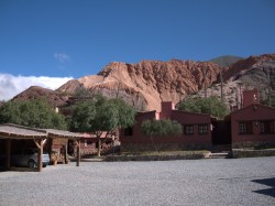
At the end of the 2nd day, we arrived in Purmamarca. Our hotel was a great little place called the Hostal Posta de Purmamarca. Click thru for their web site. Nice place and a beautiful setting. The colors of the hillsides in all directions were impressive, especially in the late day sunshine. One of my photos here is a shot of the hotel from its parking lot.

Like Tilcara, a lot of the little town was gravel streets, so pretty much everything was a little dusty. There was a great little market around the town square in Purmamarca. Our guide on the tour said they didn’t really negotiate on prices but things were not terribly expensive and as it would turn out, relatively economical compared to other towns further south. Lots of interesting bags, hats, blankets, rugs, sweaters, metalwork and jewelry. Picked up a bag for Kem here. One of the other guys on the tour, Grant, found a great sweater here. I wish I had looked for one. We didn’t need one in Purmamarca, but it’d turn out later that I’d really want a sweater.

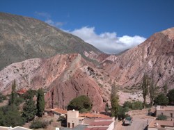
A hill right in the middle of town had a trail up to it and it made a great spot to get a birds eye view of the town and take some pictures. Herb and I hiked up and took some photos.

The next morning, our 3rd day of the tour was a pretty jam packed one. It was intended to be a ‘rest day’ where you explore Purmamarca but it was effectively only the 2nd day or the tour and the 1st day wasn’t all that taxing a ride. More than a couple of us were up for a ride that morning. Plus, the weather that morning was outstanding. Little or no wind, bright blue sky, cool temps.

The ride choice that day though was non-trivial. Especially considering it wasn’t really a ‘supported’ ride day. Route 52, our road for the day, goes through Purmamarca toward Chile and over the Andes. It quickly heads up at a steady 7% grade or more to a mountain pass that peaks at 4,170 meters. That’s about 13,600 ft. My Garmin data for the day indicated our overnight stay in Purmamarca was roughly at around 7,400 ft. Given all the hills and mountains around us it was hard to imagine we were already at altitude. So to get to the summit is a considerable climb from Purmamarca of about 6,000 ft.

Our bikes for the trip were outfitted with triple cranks and some really low gears. The extended 7% grade wasn’t going to be that bad in low gear. My main concern with doing the ride was running out of water and what the effects of altitude would be. We weren’t backed up by a van that day and there’s literally nowhere out there in that part of the world to stop and get water. It’s basically a desert and few people live there. I would have loved to give a shot at going all the way to the summit that day but it would probably have taken 5+ hours at the pace I was going and certainly more water than I had. I started out with 3 water bottles and went as far as the water allowed.

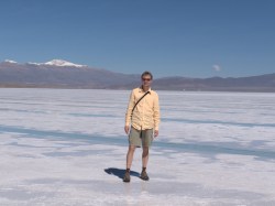
Aside from the limited water, our group was on a timetable that day. We were supposed to shuttle up to the salt flats starting at 1pm, beyond the summit on route 52. If I wanted to join that excursion I kinda wanted to get back in time to shower, grab a bite and be ready by 1.

The ride that morning was great mostly because of the stunning views and fine weather. Thankfully the road was good as well. There were a few places where it had crumbled or been washed out but otherwise much better than I imagined it would be.

These kind of climbs are not bad if you just find a gear you like that allows you to spin and then keep a pace that has you just this side of breathless. No doubt at that altitude it’s a little easier said than done to keep from being breathless but my pace was quite slow. You can look at the Garmin data again (that link has 2 days of data, so look at 2nd day) to see that my pace hovered somewhere around only 5 mph. I rode up somewhere above 10,600 ft and then the Garmin seemed to quit registering for some reason. Maybe it only quit telling me what the grade was, I don’t know. In any case, as I headed to 11,000 ft I was down to my 3rd water bottle and I wanted to be ready by 1pm so I turned around and flew back down to Purmamarca.

It may have taken 2.5 hours to climb up but to get back down it took very little time. Trust me, you want to bring a jacket or more to wear going back down. It gets cold. You’re no longer working hard and you’re going fast and you’re at altitude. I had good weather even but later in the day the clouds rolled in and I would have been riding through fog on the way back down. Assume the weather’s going to be bad.

The photo here of the road behind me was taken shortly before I made my U turn back toward Purmamarca. The view back down the mountain gives you some perspective of the winding hair pin turns you take as you ride up. Going back down the turns are a bit treacherous because many of them are strewn with gravel. You have to go pretty slow on the descent. I never got over 30 mph going back down.

It’s taking me forever to get my notes written up on the tour. Can’t believe I’m only on the 2nd day. I want to get notes down before I forget what the details of the trip were like….

Looking back on the road/mountain I've just climbed.ju

A Visit to London – Walking, Biking

Westminster Abbey

Friday was a day of tours. I’d read about and been told that the walking tours of London were worth doing and so I arranged to find one on Friday morning. The ones I had read about are every day but they differ by day. You can find all the details at www.walks.com. The one I did was the Royal London and Westminster Abbey tour. They all start at a Tube stop and you just show up, pay a fee to the tour leader and off you go. We started in Green Park and made our way down through the park to see the changing of the guard. The tour guide was very good.

The skies opened up on us after the changing of the guard and there was even some lightning and thunder. Thankfully I had an umbrella along and it wasn’t long before we were in Westminster Abbey. The Abbey has a fee to tour it unless you’re going to a service there but if you’re just going to the service you don’t actually see that much. The service seemed to be confined to one small area. Kinda strange, but it seems more of tourist spot than a church at this point.

Some very interesting memorials within the church. For example, the church is were Charles Dickens is buried. On the day I was there, June 10th, they were still commemorating the anniversary of his death (June 9th) with a couple wreaths of roses.

Our guide through the Abbey was excited to point out the ‘cartwheeling Verger’ that was about to do a service at the church. I’d never heard of him but apparently he made quite the name for himself at the recent royal wedding. See for yourself in the video.

Cycling around London

The walking tour finished in time for me to catch the Tube over to another part of the city to join a bicycle tour group done by BrakeAway Bike Tours. I did the ‘Secret London’ tour though I’m not really sure why it’s called that. The tour was a lot of fun and while there was a bit of rain along the way, mostly it was fine. The highlight was probably the Tower Bridge and being able to bike over that. We rode from about 3:30 to 8:00. Didn’t seem possible. We made lots of stops and our tour guide and ride leader, Brian, did a nice job of explaining the sights.

A Visit to London – Arrival

White Horse, Parsons Green

With the endurance test that is modern day airline travel out of the way this morning, I had the day to work out my body’s reaction to the time change – which always hits me hard – and to wander around a bit of London today.

The flight from Austin wasn’t all that bad as such things go. No delays and the flight was uneventful. Flying ‘coach’ though is just plain painful. You’re packed in there like sardines and forced to remain in an comfortable chair and position for, all tolled, about 12 hours over two legs of the trip. The flights were completely full too so very little room to spread out. I had not been able to get an aisle seat arranged in advance, but thankfully one of the folks in my row actually wanted the window and hadn’t been able to arrange that either. So we worked things out.

After getting off the airplane, you have to work your way through passport control and customs before you can get to your luggage. You get in one of those ever moving lines like at an amusement park. It was a looong line. When they finally looked at my passport they asked one question and stamped it and I was on my way. Couldn’t have taken more than 30 seconds.

I picked out a few people speaking American English but otherwise most of the people in line were non-native English speakers. Mainly that’s because the EU and UK folks have their own line to go through, and it’s shorter.

I didn’t really do much on my first day. My flight arrived around 7’ish and by 8’ish I initially found my way via the Underground to my B&B. Fiona, my B&B hostess had sent me Tube directions. ‘Take the Piccadilly Line to Earl’s Court and then the District Line to Parson’s Green’. Then it’s a little hike. Sure, no problem… I’m sure everyone’s familiar with navigating the Underground in London but me, but I’m going to jot some notes here in the event I ever want to refer back to this again. (It’s half the point of my writing this stuff down in the first place.) A little reading and other suggestions had suggested I get an Oyster card. This is the electronic card you ‘fill’ with a certain amount of money to then use to enter and exit the Tube stations. If I’d actually looked at the web site in advance I would have realized I could have bought one in advance and had it shipped to me, but I didn’t. Instead I tried to buy it from a ticket machine at the airport and failed 3 times trying to use 3 different cards. Thankfully there’s a manned both that provides assistance and I told him how many days and he suggested an amount. I paid $25 Pounds and off I went. At Earl’s Court there’s lots of platforms to choose from to make a transfer. Didn’t take me long to find though soon I was off to Fulham and the Parson’s Green station. By the time I’d gotten my luggage, found my way to the Underground, bought a ticket, ride, transfer, walk… I arrived at the B&B by 10am. Only one bag and a day pack but still, plenty to lug all that way.

Fulham Neighborhood Homes, London

The B&B is really more of a home stay. Reminds me of many of the home stays I did in New Zealand. A retired woman named Fiona has a home in the Fulham neighborhood at 17 Homestead Rd and it has up to 3 rooms that she books. It’s a completely renovated home tucked into a row of homes on what seems like a pretty quiet street. Her son lives in the basement apartment and it has its own entrance. 1st floor includes a small living, dining, kitchen area. Out back is a small patio. 2nd floor has 2 bedrooms and 2 baths. 3rd floor has one more bedroom and bath. Everything’s modern, clean and up to date. Nightly rate, 70 GBP.

B&B at 17 Homestead Rd, London

Later I wandered around the streets of the neighborhood. Found a pub named the The White Horse and had a tasty beer and a bit to eat. The picture at the very top of this posting is inside The White Horse.

The Dusty Trail

Texas Rain Lily

Having cycled in the gusty winds – gusting upwards of 30 mph at times – the last couple of days, I opted instead to hike the dusty trail this Memorial Day morning. The trail in the neighborhood is always an interesting diversion so I once again headed that way. It’s also varied enough to make it a pretty darn good workout. Today was no exception.

When I say it’s the ‘dusty trail’ I mean it literally. It hasn’t rained in a couple weeks and even at that, it wasn’t much rain and temps have been pushing 100 in the last week. Add the winds and everything is really dry. Despite that, or perhaps because of that, these pink flowers I snapped a photo of seem to be thriving along the trail. Though I’ve tried to identify these pink flowers in the past, I’ve never come across what they’re called. The only place I see them growing is places it doesn’t seem like anything else would grow. Bare, dry ground of nothing more than limestone. I’m impressed by this hardy little plant that does so well in hot, dry weather.

I really like having this trail in the neighborhood, but it’s not just a walk in the park. I tried to illustrate that with my other photo here of one of the many climbs along the trail. It can be a little like hitting the Stairmaster. I routinely huff and puff when I go out there and with the heat and humidity today I was sweating like a fieldhand on a hot August day.

Perhaps because of the holiday, there were lots of people out on the trail with me today and I marveled at at least one of them: some guy that passed me running both coming and going. We looked to be of similar age. I really want to know how he does that?

Texas Rain Lily

The 2010 Great Get-Away – Begins in Sonoma County

Though I’ve previously posted about our stay in Guerneville, I’m finally getting around to posting a few more notes about the trip I’m calling the “Great Get-Away” for 2010. The trip started with Kem and I heading to the Sonoma area with friends Jim and ML and hanging out for a long weekend in the hills above the Russian River. From that home base, we ranged down to Tomales for the Holestein 100 bike tour and up to Healdsburg and the Santa Rosa area for wine.

The house we rented was pretty nice. In addition to the view we couldn’t get enough of, you can see a shot of the back side and patio/pool in the post here. If you look close you’re see Kem lounging by the pool.

The picture of the wine was from Oakville grocery in Healdsburg. We stopped in there for a midday lunch. They make great sandwiches there. It’s right on the square in Healdsburg. It was well over 90 degrees that day and the rose wine hit the spot.

The other picture is another of the hills above the Russian River in Guerneville. We were blessed with some really great weather while we were there – as well as a full moon. I took this picture one evening from the deck of the house we rented.

Meanwhile, there was plenty of wine tasting nearby. I didn’t take the best notes in the world, but I still formed a few opinions based on the places we visited. You’ll find a few such thoughts below:

Porter Creek Porter Creek was the first place we visited for no other reason than it was one of the first up Westside road that we happened upon. That and it looked so quaint. It’s a very small place. There’s a cute little house surrounded by flowers and around the side is a very small tasting room. Maybe because it was the first we tasted I wasn’t blown away by the wines, but I do remember the Zin being excellent.
Thomas George A little bit further up Westside Rd we found Thomas George. This winery was a fair bit more upscale than the much smaller Porter Creek. Tasting are in a big wine cave. I was a big fan of their Viognier and we returned here on the way back to the house to pick one up.
Hop Kiln Hop Kiln was interesting not just for the old building they do the tastings, but also for all the other things you could taste in addition to the wine. There were mustards, oils and vinegars and someone was making and handing out samples of a chicken salad dish that was great. Unfortunately, I don’t remember anything remarkable about the wines. Maybe it’s because I was too busy tasting everything else.
Alderbrook Alderbrook had some tasty Zins.
Harvest Moon Harvest Moon had some of my favs of the trip. We ended up getting the Russian River Zin and a Cabernet that we later enjoyed at the rental house.
Hook & Ladder These wines are from the folks that used to make wines under the De Loach label. Small, family run, the name comes from the fact Cecil used to be a San Francisco firefighter in 1970. Wines were good and prices much better than most we tried in the area.
Ledson Ledson is what I call a Disneyland winery. It’s very showy and there’s something artificially showy about it. Tastings (and clearly other events) are done in the Ledson castle. Tastings are correspondingly expensive. $15 for 6 wines, $20 for 9 wines. We opted to pass on the tasting. They do, however, have a great market right in the castle and they make some great sandwiches. We had a picnic under the trees on the park-like grounds. Don’t bring your own picnic basket of food though, you can only eat food there that you buy there. If you bring your own food or wine the very visible security staff is liable to throw you off the property.
Matanzas Creek Matanzas Creek was probably my favorite of the bunch we tried. In some ways this place is probably just as upscale as Ledson but they’ve really done a nice job with the property. The lavendar fields that surround the place are not just for show. They actually harvest the stuff. It smelled great as we wandered around their garden. All the wines I tried were great. Not to be overlooked at this place was the fact that the guy helping us with tastings was very knowledable and friendly. I even remember his name: Ira. He really knew their wines and the area. In fact, I googled for Ira at Matanzas Creek and sure enough, I’m not the first person to notice how helpful Ira was. Don’t miss Matanzas Creek.